-
-
-
-
-
-
-
-
-
-
-
-
NEWBURYPORT HISTORIC MAPS
-
-
-
-
-
-
-

Newburyport Historic Maps 1640-1909
For Newburyport history enthusiasts --- and especially for those researching the history of Newburyport houses and neighborhoods --- maps of the past offer valuable context to augment information found in the written records of history. Below are links to maps of Newbury (1640 & 1700) and Newburyport (1871, 1872, 1880, 1884, 1888, 1891, 1894, 1900, 1904, and 1909. The early Newbury maps are downloadable; the later Newburyport maps can be viewed online in great detail. The 1888 and 1894 Sanborn Fire Insurance maps from the U.S. Library of Congress are downloadable. Some of the maps viewable on a commercial web site are also available for purchase.
Maps of Newbury 1640 & 1700. The file is a viewable and downloadable PDF. The 1640 map is from John J. Currier's History of Newbury, Massachusetts 1635-1902 (1902). The 1700 map was drawn by noted lawyer, editor, and historian Sidney Perley (1858-1928.
Map of Newburyport 1851. Entitled "Plan of Newburyport, Mass. from an Actual Survey," this map was published by Henry McIntyre. The link is to a viewable map at the Boston Public Library's Norman B. Leventhal Map Center.
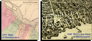
Map of Newburyport 1871. This map is from the Massachusetts State Atlas published by Stedman, Brown, & Lyon. The link is to a viewable map at a commercial web site.
Map of Newburyport 1872. This map is from the Atlas of Essex County published by D.G. Beers Co. The link is to a viewable map at a commercial web site.
Map of Newburyport Center 1872. This map is from the Atlas of Essex County published by D.G. Beers Co. The link is to a viewable map at a commercial web site.
Map of Newburyport 1880. This is a "bird's eye view" rendering that was popular in the late 19th century. These views generally were not drawn to scale, and they usually emphasized the largest industrial buildings or most notable landmarks. The map was published by E.H. Bigelow. The link is to a viewable map at the Boston Public Library's Norman B. Leventhal Map Center.
Map of Newburyport 1884. This map, in six separate sections, is from the Atlas of Essex County published by the George H. Walker Co. The link is to the viewable map sections at a commercial web site.
Map of Newburyport 1888. This map, in 14 separate sections, is a Sanborn Fire Insurance Co. map. The link is to the viewable map sections at the U.S. Library of Congress..
Map of Newburyport 1891. This map is from the Massachusetts State Atlas published by the George H. Walker Co. The link is to the viewable map at a commercial web site.
Map of Newburyport 1894. This map, in 20 separate sections, is a Sanborn Fire Insurance Co. map. The link is to the viewable map sections at the U.S. Library of Congress..
Map of Newburyport 1900. This map is from the Massachusetts State Atlas published by the George H. Walker Co. The link is to the viewable map at a commercial web site.
Map of Newburyport 1904. This map is from the Massachusetts State Atlas published by the George H. Walker Co. The link is to the viewable map at a commercial web site.
Map of Newburyport 1909. This map is from the Massachusetts State Atlas published by the George H. Walker Co. The link is to the viewable map at a commercial web site.
© 2007-2019 Newburyport Preservation Trust / Site design, text, & graphics by NPT / Site implementation by TYKATECH